Adventure Summary
There are endless places to hike and camp in Hatcher Pass which is why I spend more of my free time in Hatcher’s than any other place during the summer! Once I become a proficient backcountry skier then I will probably spend a majority of my winter free time there as well. It’s a lovely place with gorgeous views, diverse trails with varying levels of difficulty for hikers of all athletic levels and abilities, and the opportunity to eliminate distractions and reground oneself to be reminded of the truly important things in the world, which is so rare these days in our noisy lives. Time in Hatcher’s is truly refreshing!

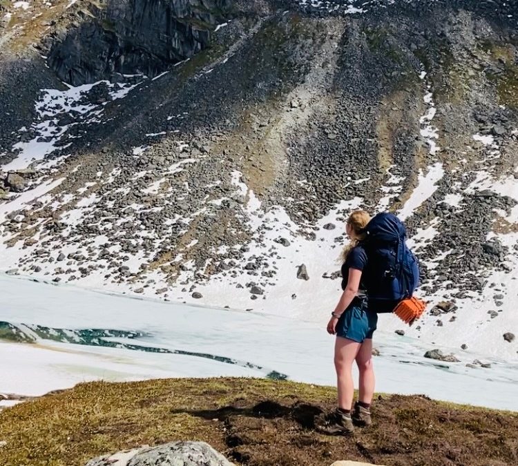
Photo taken above Gold Cord Lake in the Independence Mine Bowl of Hatcher Pass August 2, 2022.
On June 30th, Gabe (my boyfriend) and our friend, Will, left for the backcountry. We all had to work that day so we hit the trail much later than expected, at 7:00pm. Bedecked in Will’s favorite Hawaiian shirts (for no other reason than he thought it would be fun), we traveled by truck down Archangel Road, parked at the Reed Lakes trailhead, and trekked through boulder fields, snow patches, streams, mud, and heavy fog with our packs weighing approximately 50 pounds each. The trail was completely socked in. Cold, heavy clouds had settled in the Archangel Valley causing us to experience a constant misting that soaked us through. It was miserably wet and cold but the excitement of finally going on a camping trip in the mountains made up for it! We kept moving and took a few breaks so our exertion kept us warm. We eventually found the snow line at the waterfalls above the Lower Reed Lake (which was still mostly frozen over) and we made camp in an area with little snow, on one of the few designated tent camping sites. We made use of our water filters and jetboils, eating ramen and homemade freeze dried chili. We then changed out of our wet clothes, donned dry ones, filled Nalgene bottles with hot water which were placed in the bottom of our sleeping bags to keep our feet warm, and fell asleep at 1:00am.

")


I awoke the next morning at about 9:00am to sunlight streaming through the tent. I quickly unzipped my tent door and rain fly. The view before me was absolutely breathtaking! The snowy mountain sides, icy lake, bluebird skies, and sun rays took my breath away and gave me a feeling of peace and contentment. It was the feeling of being home. As I breathed in the fresh Alpine air I heard the guys in the tent next to me yelling at an Arctic Ground Squirrel that had crawled into Will’s food bag and was eating his Mountain House. As humorous as it was, I was grateful I had hung my food in a dry bag, from a large rock to prevent the ground squirrels from reaching it. That’s a pro-hiker tip for you. Hanging food bags from tall rocks in the Alpine keeps the ground squirrels out of them.
")
")
")
The three of us got up and made breakfast; instant oatmeal and more ramen (backpackers’ bread and butter). We then laid out specific articles of clothing that were still wet, on rocks, in the sunshine, for them to dry out. We pulled out our eggshell sleeping mats and laid them on the mountain side where we basked in the sunshine, talking about life, and waving to the first hikers of the morning who passed by our campsite.
The guys packed all their belongings and left at about noon to go further up in the mountains where they would spend four more days backpacking and camping from mountain to mountain, exploring multiple glaciers, and skiing and snowboarding every snowy slope they could find.
")
")
I remained behind. An eight mile hike with a 50 pound pack would be enough of an adventure for me. So I spent a few more hours sketching, reading, and sunbathing in the mountains. At about 2:00pm I packed my belongings and headed back down the trail. I journeyed the sunny four miles back to the trailhead and arrived at my truck at about 5:00pm.


The adventure didn’t stop there. After driving back from Archangel Valley and out of Hatcher Pass I stopped at the Valley Hotel for a milkshake, as per hiking tradition.
Location and Directions
Hatcher Pass: To get to Hatcher Pass from Palmer, you’ll take the Glenn Highway North out of Palmer and then turn left to go west on Palmer-Fishhook Road. Just follow Palmer-Fishhook for about 15 minutes and it will curve northward and take you up into the Talkeetna Mountains to Hatcher Pass.
I have seen many people drive new motorhomes up to Hatcher Pass but I do not recommend taking a large RV, an old motorhome, or any vehicle with a weak engine (especially if they are pulling a heavy load) up to Hatcher Pass because there are several very steep hills. Instead, park heavy RV’s and old motorhomes at a pull off next to the Little Susitna Bridge or somewhere in Palmer and drive in another vehicle, if possible.
History fun fact: In the late 1800’s many gold miners were attracted to this area in the Talkeetna mountains because of the naturally occurring gold discovered in some of the creeks and in the ground. The miners and homesteaders used to pass through the Talkeetna mountains to Willow using the easiest route possible. This route became known as Hatcher Pass and the trail is now the paved Palmer-Fishhook Road and the dirt Willow-Fishhook Road.
Directions to Various Locations of Interest in Hatcher Pass: The road that leads to Hatcher Pass is the Palmer Fishhook Road. Palmer Fishhook travels northward toward the mountains and has several pull offs and a few dirt roads that branch off to camp grounds, trailheads, and ski slopes.
Before entering Hatcher Pass, you can take a left (to go west) on E. Edgerton Parks Rd and then take a right (north) on N. Mountain Trails Dr. where you can find the Government Peak Chalet and the trailhead to hike two of the nearest mountains in the Talkeetna Mountain Range, Government Peak and Blueberry Knoll. These hikes often take my friends and me three or four hours. The Government Peak Chalet is a lovely venue with a gorgeous view. Weddings are frequently held there. In the winter, the state maintains several cross country ski trails at the Government Peak/Blueberry Knoll trailhead.
If you do not turn left but continue to follow Palmer Fishhook northward into the mountains you’ll see the new Skeetawk Ski Resort to the left and the Government Peak Recreation Site (not to be confused with the Government Peak trailhead on the other side of the mountain) to your right (which has a few campsites and picnic tables).
Eventually you’ll come to a very sharp hairpin turn that leads up a steep mountain side. If you go straight instead of taking the hairpin turn, you’ll find a parking lot, the Gold Mint trailhead, and a few camping spots.
If you continue around the hairpin turn and up the mountainside you’ll see a few lookout points to the left and then to the right you’ll find a dirt road called Archangel Road that leads to Archangel Valley. There are many trails that branch off Archangel, and Reed Lakes trail (the one we just hiked) is one of them. This road is occasionally grated, but only from the pavement to the bridge. There is now a dirt parking lot right before the bridge in which folks with delicate vehicles can park. If you cross the bridge, be prepared for a dirt road with massive boulders sticking up that can easily rip the transmission out from the bottom of a car. I’ve never seen a maintenance crew on the other side of the Archangel bridge so I don’t expect the poor condition of this road to change any time soon. I do not recommend driving this part of the road unless you’ve got a tough truck that is built for such conditions.

If you stay on Palmer Fishhook instead of turning right on to Archangel you’ll meander around a few mountain turns and then on the right you’ll see a parking lot with some outhouses at the Marmot trailhead.
To the left you can see what Archangel Valley looks like from the top of Marmot. Photo taken September 8, 2022.
If you continue on Palmer-Fishhook you’ll see a dirt road to the left that leads to the summit of the pass and then will go downward and out of the Talkeetna mountains to the town of Willow, approximately 30 miles away. This dirt road is called Willow-Fishhook Road and is often wash-boardy and riddled with potholes due to the massive amounts of traffic. I do not recommend driving the dirt road from Summit to Willow in a vehicle that is not specifically designed for off-roading.
If you continue on Palmer Fishhook rather than turning left to go to Summit, to your right you’ll see the Red Hatcher Pass lodge and adorable red A-frame cabins that are for rent year round.
If you pass the red A-frames and stay on Palmer Fishhook you’ll find yourself passing through a long parking lot with outhouses and a fee station on your right. You can park here (if the gate is locked after hours of operation (10am – 6pm) and pay at the fee station to hike around the Independence Mine Bowl.
If the gate is open during operation hours you can drive up to the mine and park and pay there at the fee station next to the outhouses. From there you can explore the Independence Mine Bowl, just be sure not to get locked in. It is here at Independence Mine in Hatcher’s that Palmer Fishhook ends.


Photos of Independence Mine Buildings taken October 4, 2022.

Directions to Trails in Hatcher’s: There are several popular hiking trails that branch off Archangel Road, exist around the lakes of Summit, and run along the mountain peaks of the Independence Mine Bowl. Here are general directions to just a few of the favorites.
The trails off Archangel are often very long and take many hours to fully hike. These trails are ideal for backpacking and camping. For example, our late night hike to Reed Lakes took about five hours, we spent the night, and I hiked back down the following morning in three hours (with a 50 pound pack).

If you have a vehicle that can make it up the steep, wash-boardy, dirt road from Palmer-Fishhook to Summit, there are wonderful little hiking trails around Summit Lake and around the April Bowl Lake. These hikes usually take visitors about an hour to complete as well.
A dog named Ragnar, belonging to a random stranger who I befriended while on a solo hike around April Bowl, above Summit Lake, August 21, 2022.

The hike to Gold Cord Lake is an old favorite! The trail begins at the VERY end of the pavement of the Palmer-Fishhook Road, near the mine. The trailhead will be to the right of the very end of the paved part of the road. The dirt road is a private drive. For most visitors, it only takes about an hour to hike. I usually take visiting family and friends to this one and we usually take an icy dip in the icy blue lake if it’s sunny. I highly recommend this hike.
Photo to the left is of Gold Cord Lake August 2, 2022 and photo to the right is of Gold Cord Lake October 4, 2022.
")
Maintenance
The road that leads to Hatcher Pass is the Palmer-Fishhook Road. Palmer-Fishhook travels northward toward the mountains and is well maintained all the way to Hatcher Pass. The dirt roads in Hatcher’s are less frequently maintained and not as easily accessible. I do not recommend driving these dirt roads unless you have a very dependable vehicle that can handle very rough road conditions.
The entirety of Palmer Fishhook is paved and well-maintained throughout the year, even during the winter so that skiers and snowboarders can access the slopes. Additionally, the many parking lots, outhouses, and trailheads are regularly well-maintained by the State of Alaska.
The hiking trails are kept neat and tidy through the help of hikers who care about these places. Please continue doing your part to keep our beloved mountains clean and litter free.
For safety purposes, you cannot camp within a ¼ mile of the road. There are very few official camping spots (only located at Government Peak Recreation Site, and a few at the Lower Reed Lake). When most people camp in Hatcher Pass they are more than ¼ mile from the road, in the depths of the mountains where there are no restrooms, so it’s imperative that they pack out their toilet paper in order to maintain litter free recreation areas. The Leave No Trace website has lots of helpful articles on disposing of toilet paper and feminine hygiene products while in the backcountry. This link will take you to their website where you can read peruse several articles and watch short videos on disposing of TP and the like: https://lnt.org/?s=Toilet+paper
")
There are outhouses located along the road. A few years ago a stone wall was built at the Lower Reed Lake for privacy when relieving oneself. It is far from luxurious but it does provide some much needed coverage in this highly trafficked area.
Every winter, ski trails are groomed at Government Peak/Blueberry Knoll, Archangel Road, Independence Mine, and Summit (for backcountry skiers and cross country skiers) and of course, Skeetawk Ski Resort. If you’d like to learn more about skiers in Hatcher Pass, I recommend stopping in at Skeetawk or our local ski shop, Backcountry Bike and Ski at 132 W Arctic Ave, Palmer, AK 99645 for more information.
There are also a few huts spotted throughout the mountains in locations I have been asked not to disclose. If you’re interested in finding them. Then go exploring! Hint: they’re usually at the very end of long trails. These huts used to be maintained by Hutmeisters. These hutmeisters were individuals who volunteered to live in the mountains most of the summer to maintain the huts, haul sewage from outhouses, repair damaged parts of the buildings due to weather or hungry and demented Marmots who like to eat plywood, and do whatever else needed to be done to ensure these huts have a long life. However, when the program was disbanded a few years ago, the maintenance has fallen to those who frequent the cabins. If you happen to find a hut, please be respectful and leave it better than you found it. There are occasionally outhouses near the huts as well. These were maintained through the hut meister program but I’m unsure who (if anyone) is cleaning these out.
Safety Information
Gates: There are three gates in Hatcher Pass (one at the Archangel turn off, one at the Summit turn off, and one at the Independence Mine Road) and they are locked throughout the entire winter and do not open until mid-June once the snow has mostly cleared from the road. Even after the gates are open, the gate to Independence Mine is locked each night at 6pm. So if you visit in the afternoon/evening and decide to go exploring, be sure to make it back to your car before 6pm. If you’re not sure you can make it back in time then park in the lower parking lot. It’s only about a mile from the lower lot to the mine so it’s not very far to walk.
As a reference, to the right is an image of my cousin standing at the Independence Mine Gate on May 25, 2022.

Animals: I have never seen any bears in the Independence Mine Bowl and up at Summit but it’s always possible. I have seen many bears throughout the Archangel Valley which just on the other side of the Independence Mine Bowl. Always hike prepared with some sort of protection whether it’s a group of loud friends, an airhorn, bear spray, and/or a gun. If you see any wildlife, be sure to give them a wide berth, make noise to prevent startling them, and always be aware of your surroundings.
Pets: Keep dogs on leashes when hiking in areas with other people. I had a friend who recently went hiking on an Anchorage trail and said she saw a dog covered in blood because he had been attacked by someone else’s dog. Some dogs act very differently in the wild and around other animals, especially when in a new environment. Don’t take the chance of your dog being attacked by another dog, or attacking another dog or person.
Plants: There are lots of toxic Devil’s Club and poisonous Baneberry in some areas. Be cautious when touching plants or picking berries.
Water: The water is so clear and beautiful in the mountains, and probably safe to drink in many areas. However I always filter or boil my water when on long trips because if run off from animals and humans, specifically excrement that is inevitably in the water. Be sure to filter your water, I know of someone who got Beaver fever while drinking from what seemed to be a clean mountain spring in the mountains near Eagle River.
Avalanches: Avalanches are only a threat in the winter and spring. So be aware of snow fall, current conditions, ski slopes, motorized and non-motorized zones for snow machines, avalanche zones of the past, and current avalanche warnings. Check in with Skeetawk, Backcountry Bike and Ski, and Hatcher Pass Avalanche Center (https://hpavalanche.org/forecast/hatcherpass/).
Foraging and Trail Snacks
Many people forage for blueberries in late summer/early fall in the Hatcher Pass area. There are also many rosehips and bluebells to eat along the trails throughout the summer. Be sure to watch out for poisonous berries because they are out there.
To the right is my bowl of blueberries from last fall. Photo taken August 31, 2022. It rained the entire time and all my clothes were completely soaked through, but it was worth it. I have been rationing them all winter and I still have a few left for blueberry pancakes this summer!

Additional Points of Interest
The Independence Mine State Historical Park is still in the process of being restored and preserved for future generations and is well maintained by their summer staff members. You can walk around the old mine buildings and even pay for a guided tour and get access to some of the buildings that are closed off to the public. They lock the gate each night at 6pm to prevent vehicles from driving up close to the historic mine buildings during the night, so be sure not to get locked in. If you want to night hike, park in the long, lower parking lot where you won’t get locked in and feel free to cross the gate on foot to explore the Independence Mine Bowl. There are informational signs around the grounds and in several of the unlocked buildings. They also offer mine tours for $15. Salmonberry Tours leads the mine tours as well as offer other package deals. You can visit their website here for more information: https://www.salmonberrytours.com/
History fun fact: There used to be an entire town around the Independence mine buildings. In this town lived the families of the miners. Its name was Boomtown and there was a saloon on its outskirts called Seattle. There were also many smaller mines in various claims in this area. As you explore you will probably find pieces of metal and wood from old houses and mine machinery. Most, if not all of the old mine shafts have been closed up and are no longer in use. The mine shafts are now structurally unsound due to decades of erosion, earthquakes, and no maintenance. Since much of this history is being lost to time as the mountains reclaim themselves, my good friend and brother, Adam Christiansen, has documented many of the carbide drawings in Hatcher Pass. He has produced a mini documentary which you can watch here: https://www.youtube.com/watch?v=-TbTt22kTP8 or you can view his photo gallery on his website here: https://www.akcarbide.com/

Hatcher Pass Lodge is the iconic symbol for Hatcher Pass with its unique A-frame cabins. If you’re interested in reserving one of these high demand cabins, you can learn more and check availability here: https://www.hatcherpasslodge.com/
Winter Sports: Many people go to Hatcher’s to ski, snowboard, sled, and snowmachine. Be sure you are up to date and knowledgeable about avalanche zones and non-motorized zones in order to protect yourself and others before shredding the gnar.
Skeetawk is a rapidly growing ski resort that has been in operation for approximately three or four years. To help fund this project and enjoy a pow day. Stop in or visit here for more info: https://skeetawk.com/
Turner’s Corner is the first gas station on your right as you go south and come down from Hatcher Pass via Palmer-Fishhook. My friends and I would usually stop for ice cream after hiking and Turner’s corner is the first place with ice cream so we’ve frequented it regularly for many years. It is located at 8238 Turner Rd, Palmer, AK 99645
Hatcher Pass Gift Shop is right after Turner’s Corner on the descent from Hatcher’s. It is located at 8380 N Palmer Fishhook, Palmer, AK 99645.

One of the Hatcher Pass A-frames. Photo taken by Gabe K. February 26, 2022.
More Info
If you’d like to find more information on trails, plants, animals, and history visit the Palmer Visitor Information Center and Museum at 723 S. Valley Way. https://visitpalmer.com/ and https://palmermuseum.org/
If you have questions about specific trails I recommend using the All Trails app (https://www.alltrails.com/lists/hatcher-pass) and/or the Gaia app, visiting online at https://visitpalmer.com/hiking-backpacking/, https://dnr.alaska.gov/parks/aspunits/matsu/matsuindex.htm or visiting me at the Palmer Visitor Information Center and Museum.
Have fun and keep exploring!!

The Upper Reed Lake. Photo taken July 10, 2022.
About the Author

Kyndle is a native Alaskan, born and raised in Palmer. She spends her winters teaching and her summers hiking. When she’s not hiking, she’s either working at the Visitor Information Center/Museum, Friday Flings, or other local community events. She’s been to a lot of places but Palmer is her favorite small town. After each hike this summer, she will publish a report about her adventures including important details regarding current trail conditions, available restrooms, ADA accessibility, foraging, trail snacks, history, and much more!