Adventure Summary
The Crevasse-Moraine trails are a system of looping dirt trails through a heavily wooded part of the Mat-Su Valley. One shouldn’t expect any profound mountain views but these trails are ideal for trail runners, mountain bicyclists, and anyone looking for a refreshing forest walk.
The Crevasse-Moraine Trail System is only a portion of the much larger Matanuska Greenbelt Trail System. The Matanuska Greenbelt trail system can be accessed from six different trailheads; the Crevasse-Moraine Trailhead, Long Lake Trailhead, Mat-Su College Trailhead, Matanuska Experiment Farm Kin-Win Trailhead, Matanuska Lake Trailhead, and Snodgrass Hall Trailhead. Some of these trailheads are easier to access than others. I have frequently parked at the Kin-Win Trailhead and hiked among the lakes behind the Matanuska Experiment Farm but I was unaware of the most northern portion of this trail system and its Crevasse-Moraine Trailhead.
A close friend recently decided to move out of state so he invited my boyfriend and me to go on a hike with him as he explained his decision and discussed what the future may hold. He is very familiar with the Crevasse-Moraine trails (having run the trails often) and suggested that we hike it while we chat. Since I had never hiked Crevasse-Moraine I was eager to hike these trails with him.
")
We met at the trailhead, lathered ourselves in bug dope, and began hiking. I was amazed by the number of loops that this trail system consisted of. I couldn’t make much sense of it even with the map. I could have spent a few days just wandering around these loops but we only spent a few hours. We kept to the right every time we were faced with a fork in the trail. This trail led us up and down a few hills, passed the landfill (where the ravens and majestic bald eagles were abundant), and around to the Mat-Su College trailhead.
We came back the same way. It was a lovely forest walk! It was obvious that these trails are regularly used by bicyclists and trail runners.
Location and Directions
The trailhead begins in a subdivision off the Palmer Wasilla Highway. While on the Palmer Wasilla Highway, you’ll turn south on Loma Prieta Dr. Then you’ll simply follow Loma Prieta around a few bends until it ends at the Crevasse Moraine trailhead.
The trailhead consists of a dirt parking lot, an outhouse, and a large map of all the loops. Because of the many twists and turns of the trail loops, I recommend taking a photo of the map to carry with you on your phone, printing a map here: https://visitpalmer.com/hiking-backpacking/, or getting a map from the Palmer Museum and Visitor Information Center. I also recommend packing toilet paper with you. The outhouses are usually well-maintained by the borough but you never know when a large passel of hikers have come through and depleted the toilet paper in the outhouses. I had to learn the hard way. So, take my advice, ALWAYS pack TP.
There is a $5 parking fee at the trailhead unless you have a Mat-Su Borough pass on your windshield. You can buy the annual pass for $40 here: https://ecommerce.matsugov.us/Pages/CD/AnnualParking.aspx This pass is good for any and every park maintained by the Mat-Su Borough. For another $60 you can also purchase an annual pass for every state maintained park here: https://dnr.alaska.gov/parks/passes. In sum, it costs me $100 to park for free at any trailhead in the Valley. For someone who hikes regularly during the summer, I save a lot of money with the annual passes. To hike two or three times a week, camp at least once a month, and drive up to Hatcher’s a few times during the winter to learn how to backcountry ski. I save at least $100 and a lot of time by buying the passes at the beginning of the year rather than paying $5 every time I park at a park.
To the right you can see my truck sitting in the gravel parking lot, with my parking sticker in the window, and the outhouse in the background.
")

History fun fact: When the Matanuska Colony was established in 1935, colonists from Minnesota, Michigan, and Wisconsin were given 40 acres of land and limitless debt to start a farming community. However, this land (where Crevasse Moraine is) was off limits. The colonists were tasked with clearing their own farmland which was a very difficult job to begin with and clearing the land around what is now Crevasse Moraine, to use it as farmland, would have been practically impossible for them. The area that now consists of the Crevasse Moraine Trails and
much of the Matanuska Greenbelt Trail System was deemed to be terrible farmland due to its rocky hills and steep slopes that had been carved out by the retreating Matanuska and Knik glaciers a few thousand years ago. Though it was not suitable land for farming it is certainly ideal land for hiking, biking, running, fishing, and swimming. Many of the lakes located throughout the Matanuska Greenbelt trail system are difficult to access but are certainly a pleasant surprise to hot and sweaty hikers. All of these trails are full of nature’s pleasant surprises.
Photo acquired through the Palmer Museum and Visitor Information Center Matanuska Valley Photo Project. https://www.mvhphotoproject.org/artifacts/colony-farm-1
Maintenance
Other than the outhouses, it appears these trails require little maintenance. I observed no erosion in this heavily forested area. The only signs of maintenance I saw were some cut trees. Occasionally, trees will get blown over (usually during our strong winter winds) and fall across the trails, blocking hiker access. So the borough will send out workers to cut the trees in logs so they can be removed from the trail and set to the side.
Safety Information
Animals: This is a heavily forested area so bear sightings are occasional (once every few years) and moose sightings are regular. My friend, with whom I was hiking, told me he ran into a moose once while jogging these trails. So, be prepared. Bring some loud friends, an air horn, bear spray, and/or a high caliber hand-gun if you are trained to use it. Making noise will help animals hear you from a distance and prevent you from startling them. When an animal is startled it will usually act aggressively. So make noise, avoid animals, give them their space, and if you are charged, do whatever you need to do to scare them away and protect yourself.
Foraging and Trail Snacks
I didn’t see anything obviously edible on this trip but I’m sure people with much more foraging experience than me could have found loads of edible plants to make use of. If you’re an experienced forager, checking out these long and obscure trails might be very advantageous!
Additional Points of Interest
")
There was a lot of wildlife in the area next to the dump. I saw countless ravens and eagles flying and nesting overhead. I also discovered a little wood frog.
The Crevasse Moraine trail is right next to the landfill, the Mat-Su college, and leads to some connector trails that will take you to the Matanuska Experiment Farm, several hidden lakes, and the Matanuska Lake campground.
I had never seen the landfill in action so I found that fascinating! I watched through the fence as landfill vehicles motored about. We were far enough away that we couldn’t detect any smells.
")
Update 7/26/23: For many years, very little has been known about these guys and how they are able to survive Alaska winters. I was pleased to find this mysterious little one. Most frogs in warmer climates hibernate in the depths of lakes where they get cold but do not freeze. Now we know, unlike most frogs, wood frogs are able to survive the harsh winters in Alaska by freezing during the winter. They do this by pumping their body full of glucose ((100 times the normal levels (diabetics experience 2 to 10 times the normal amount of glucose)) to prevent their individual cells from freezing. Essentially, all the water in their body freezes between the layers of skin and muscles, and in between the cells, but the cells do not freeze. This allows the frogs to thaw during the spring! Click here to learn more! https://www.nps.gov/gaar/learn/nature/wood-frog-page-2.htm Shout out to the folks at My Favorite Realty on Facebook who read my blog and shared this fun fact with me!
")
We followed the trail to the Mat-Su college but didn’t make it the whole way because we were short on time. I hope to go back and do some more exploring later.
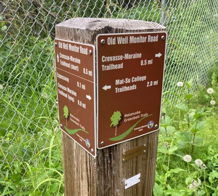
On our short hike we also discovered several posts with directions to various trails (as seen above in the featured photo).
")
I also noted that at the beginning of our walk, as we left the parking lot, to our left there were some open fields and additional outhouses. This would be an ideal location for a low key game of ultimate frisbee, baseball practice, or a good old game of tag for the little ones. I’m always on the lookout for places to play in areas where we don’t have to worry about crowds.
")
More Info
If you’d like to find more information on trails, plants, animals, and history, visit the Palmer Visitor Information Center and Museum at 723 S. Valley Way. https://visitpalmer.com/ and https://palmermuseum.org/
If you have questions about specific trails I recommend using the All Trails app and/or the Gaia app, visiting online at https://visitpalmer.com/hiking-backpacking/, https://dnr.alaska.gov/parks/aspunits/matsu/matsuindex.htm or visiting me at the Palmer Visitor Information Center and Museum.
Have fun and keep exploring!!
About the Author

Kyndle is a native Alaskan, born and raised in Palmer. She spends her winters teaching and her summers hiking. When she’s not hiking, she’s either working at the Visitor Information Center/Museum, Friday Flings, or other local community events. She’s been to a lot of places but Palmer is her favorite small town. After each hike this summer, she will publish a report about her adventures including important details regarding current trail conditions, available restrooms, ADA accessibility, foraging, trail snacks, history, and much more!